The current version is 1.3.0
Please read the ReadMe.txt file included with the setup program. It contains more detailed information about the program (which does not have a help file).
MagWay is a Windows 32 bit program, you will need Windows 9x, Windows NT, Windows 2000, or Windows ME in order to run it.
There are two copies of the installation, the first includes the Visual Basic 6 runtime and OLE libraries and is around 4MB in size.
Get it here (Full 3.9MB)
The second, does not include the VB6 runtimes (if you are sure you already have them) and is around 3MB in size.
Get it here (Min 2.8MB)
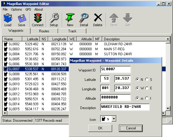
Typical Screen Shot of MagWay (1.1.0)
Release 1.3.0
| Fixed a problem downloading multiple routes from the GPS. | ||
| Adds OSGB sheet ID support. | ||
| Adds UTM support (WGS84 datum only in this version). | ||
| Adds support for OS Northern Ireland grid references. | ||
| Adds support for OS Republic of Ireland grid references. | ||
| Changes OSGB, OSNI, and OSRoI grid reference calculation to use NGR89. | ||
| Fixes the datum to WGS84 - datum support to be added to a future release. |
Release 1.2.1
| Fixed a rounding error in the OSGB routines (my fault). | ||
| Fixed an offset error in the OSGB routines (OS documentation!) |
Release 1.2.0
| Fixed spelling of 'Ordnance' Survey in the datums! | ||
| Added the ability to edit waypoints in OSGB grid reference format. |
Release 1.1.3
| Added height unit preference to the options screen, you can now select between; feet, metres, and "don't care". |
Release 1.1.2
| Fixed another bug for international users that use the comma as a decimal. | ||
| Added the ability to set the datum used in your GPS. TAKE CARE, see the datum notes in the readme.txt file. | ||
| Added datum checking when loading from file. | ||
| Added icon letter validation when downloading from GPS. Some other programs appear to upload waypoints with invalid icons, MagWay will correct these when downloading. | ||
| Added the Icon letter back to the Waypoint screen, to allow sorting by Icon. |
Release 1.1.1
| Fixed a file IO bug that crept into version 1.1.0 - Sorry! | ||
| Also took to opportunity to make file IO more robust. |
Release 1.1.0
| Now displays the waypoint Icon on the main waypoint screen. | ||
| Separated various fields for 'my' convenience. | ||
| Added the trackpoint number to the track screen. | ||
| You can now sort (ascending and descending) on any field in the waypoint and track screens. | ||
| You can now display gridlines on the screens. | ||
| Added the ability to 'append' data to existing files. |
Release 1.0.1
| Added 'Loading waypoints. Please wait..." dialog when editing existing routes. This removes the ability for the user to repeatedly click the edit button when working with large numbers of waypoints. | ||
| Now clears the route description from route editor when a route is deleted. | ||
| Fixed extraneous error messages after you canceled a file load or save. | ||
| Changed 'Connect' label to read 'Disconn' when you are connected. | ||
| Added the ability to select and delete multiple waypoints. | ||
| Now warns you if you try to save to a file that already exists. |
Release 1.0.0
| Initial public release. |
Here are some waypoint files to play with:
London Underground stations - 270 records
Scottish Munroes (peaks over 3000' high) - 517 records
UK Motorway Junctions and Service stations (zip file) [1]
[1] This is based on Garmin data originated by Paul Ross, I have updated it for recent motorway name and junction number changes around Manchester. I've also split it up into individual files, one for each motorway to keep the number of waypoints you need to upload more manageable.
Last modified 23 May 2008