Download from here: OSGB.zip
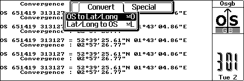
This little utility enables UK users to convert back and forth between Ordnance Survey National Grid co-ordinates and Latitude/Longitude. In addition, it provides a value for the OS Grid convergence at that point.
This program is released as Freeware. You may redistribute freely as long as you include this text file with the program.
The author accepts no responsibility for any consequences of the use of this program.
The program is written in OPL on a Psion 3a so it should be OK on a 3c as well, it will probably run ok on the Sienna though the text may not be formatted very well. If anyone wants to port it to the Series 5 contact me at the address below.
Acknowledgements go to David Harper from whom I cribbed some of this text. An on-line version of this program can be found at his web page.
A port of this program to the Psion series 5 has been done by John Wilson, take a look at his web page.
How's it done?
You can download the Ordnance Survey paper on the formulae used by OSGB from my site here:
http://www.gps.gov.uk/additionalInfo/images/A guide to coord.pdf
You'll need Adobe Acrobat reader to read this file.
Versions
This program uses six-digit co-ordinates (accurate to one metre) rather than the more commonly used three-digit version (accurate to 100 metres).
Example
Suppose you wish to find the latitude and longitude for a point whose hundred-metre grid reference is 123456 (that is an easting of 123 and a northing of 456).
At the bottom left hand corner of the map you will see the grid co-ordinates of the corner itself given as two six-figure numbers, in the format of one tiny digit followed by two large ones (these are the kilometre figures) followed by three tiny zeros (representing metres)
Say that the eastings figure is 510000 (tiny 5, large 10, tiny 000). This means that the hundred-kilometre prefix is 5, and your six-figure easting is therefore 512300. Remember that the third digit of your original easting measures tenths of kilometre (i.e. the nearest 100 metres).
If the northings figure at the bottom left-hand corner is 240000 (tiny 2, large 40, tiny 000) then your six-figure northing is 245600.
The latitude and longitude is displayed to the nearest 1/100 of a second arc. This is roughly equivalent to a 1-metre resolution.
The convergence 'C' at any point is the angle between the 'North-South' grid line and the direction of the meridian at that point.
The Grid Bearing + C = True Bearing.
For the National Grid C will be zero on the Easting 400000 (2degW). It is positive to the east and negative to the west of this grid line.
The following hotkeys are supported:
Psion-o or o | Bring up the OS grid ref. entry form. |
Psion-l or l | Bring up the Lat./Long entry form. |
Psion-x | Exit the program. |
Menu | Display a menu of the above. |